
Ever since humans started moving, there has been a constant need for maps and navigational devices. One such navigational device is GPS. GPS, or Global Positioning Device, is a navigational device that, with the help of satellites, helps you determine your precise location, speed, and time anywhere on the Earth.
The GPS is made up of a network of orbiting satellites, ground control stations, and GPS receivers that communicate with each other. With a wide range of applications in transportation, communication, agriculture, etc. GPS has become an essential tool in modern society.
GPStracker247 team brings a detailed overview of the History of GPS. Let’s dive straight into the article.
The first satellite-based navigation system was set up in 1964, initially for a naval vessel and later for public use as well. The first operational device was known as NAVSAT, Transit, and NNSS ( Navy Navigation Satellite System). GPS was a successor of this Navigation System. The first satellite was launched in 1978, and the system became completely operational in the 1990s. The early capabilities of GPS were limited, but it was continuously upgraded and improved.
Table of Contents
Birth of Navigation
The oldest form of navigational devices is maps. The earliest man-made map dates back to 700 BC. It is a Babylonian map of the world carved on stone. The maps were followed by the discovery of a compass which is believed to be in the early 11th century in China, followed by Europe in the late 12th century.
Way back in 1957, Russia launched Sputnik, the very first satellite to orbit Earth. It was a really big deal! The scientists at the Applied Physics Lab (APL) at John Hopkins University were fascinated by what they observed. They found that the satellite emitted a radio signal, and when it got closer to Earth, the radio signal frequency increased. Then, as the satellite moved away, the frequency decreased. This interesting effect is now known as the Doppler effect. And it’s pretty cool because it led to the development of navigational systems using satellites. Who would have thought that one little satellite could have such a big impact on the world?
The Air Force, along with the efforts of Dr. Ivan Getting, the founding president of Aerospace, formed a satellite navigation program named 621-B. The Transit system came into use in 1964 and served as the most reliable navigation device till its successor came in the form of GPS. GPS technology started to become available in some cell phones in the late 1990s, but the first cellphone with built-in GPS was not released until 2002. It also began showing up in automobiles, and in 2000 the government decided to add 3 more satellites for additional GPS signals.
What was the need behind a Satellite-Based Navigation System?
During the cold war, the military needed accurate navigational systems for their ariel and naval vessels and to support various operations. This led to efforts toward Transit in the early 1960s.By 1964, a constellation of five satellites was fully operational. Transit was accurate to 10s of meters and is credited with increasing the accuracy of maps by nearly two orders of magnitude.
Birth of GPS
GPS was developed as a successor to the Transit navigational system. In 1972, an Airforce colonel was tasked with overseeing the satellite navigation program. Col. Bradford Parkinson and his team developed a concept that took the best aspects of the Transit System. After conducting hundreds of tests from 1973 to 1978, the first set of GPS satellites was launched.
The system became fully operational in the 1990s.With the launch of the first GPS-based cellphone Benefone Esc! GPS became available for everyone. The end of the “Selective Availability” program of the US government and the fall in the cost of GPS receivers and transmitters from thousands of dollars to a few hundred dollars contributed significantly to making GPS available to the masses.

The early capabilities of GPS were limited to today’s standards. Initially, GPS was entirely used for military purposes. One of the early achievements of GPS was during the Gulf War when the US military used GPS extensively to guide its aircraft and missiles which led to increased accuracy in operations.
Expansion, Commercial Applications of GPS
The Public use of GPS was allowed by the US government on July 17, 1995. Prior to that, the GPS was strictly used for military purposes.
The decision to make GPS available for civilian use was announced by President Bill Clinton in 1996. This allowed private individuals to access GPS signals without any restrictions. Since then, GPS has become an essential tool for navigation and location-based services across various industries and applications.
The GPS device relies on at least four satellites to determine the exact location of the user, this provides high accuracy in real life. The navigational aspect of the GPS is what it is most well known for but nowadays it is used in tracking things and making maps and surveying places. The chronometers being used in satellites provide exact time and the receiver adjusts its clock accordingly.
Modern GPS
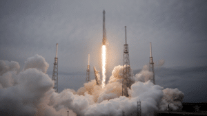
Did you know that back in 2000, scientists realized that GPS technology needed to be enhanced to meet both military and civilian needs? That’s when they launched the Block II satellite in 1989, which had five different configurations and capabilities. Then, in 2018, the first GPS III satellite was launched on SpaceX Falcon 9, followed by three more launches in 2019 and 2020, with the final six satellites planned to launch by 2023. It’s pretty amazing how GPS technology has impacted our world! In fact, one report found that GPS satellites have generated almost $1.4 trillion in economic benefits since the 1980s.
A very important tool in the operation of data networks and the financial system is PNT synchronization. It is used to study earthquakes, volcanoes, and tectonic plate changes in the region. It is used to study the effects of these phenomena on the accuracy of GPS and other positioning systems. GPS is used for precision agriculture, which includes optimizing crop yields and minimizing environmental impact. According to a 2019 study, American consumers saved more than 52 billion gallons of fuel and drove more than a trillion fewer miles.
Uses of GPS in Everyday Life
GPS has had a profound impact on our lives, with its applications extending to transportation, communication, agriculture, and many other fields. Ever since its integration with vehicles, GPS has assisted drivers and operators with accurate data on speed, time, location, etc. It has also helped to optimize and reduce fuel consumption.
Smartphones and other devices rely on GPS to use location-based services such as maps, social-media check-ins, and real-time traffic updates. A vital impact of GPS was in emergency response systems, allowing first responders to locate and respond to emergencies more quickly.
Some daily life applications of GPS:-
- Navigation systems:- Ranging from cars to airplanes, GPS assists all vehicles, smartphone applications, and handheld GPS devices with navigation. These devices use GPS signals to provide accurate directions and information on the traffic to help them reach their destination.
- Location-based services:- Many applications on a smartphone require your accurate and real-time location for the provided services, eg. Uber. These applications rely on GPS to provide accurate location of users for a better service.
- Fitness trackers:- In the present time, most fitness trackers are fitted with a GPS device. The purpose of the device is to use GPS signals to track the user’s distance, pace, and route during an outdoor workout like running, cycling, trekking, etc. providing accurate data to analyze the workout.
- Personal safety:- GPS technology is also used for the personal safety of users. Watches and bracelets fitted with a GPS device are used to monitor children, the elderly, etc.
The Future of GPS
As more and more users are relying on this navigation system, new challenges and vulnerabilities have emerged like jamming, spoofing, and cybersecurity threats. These threats can disrupt or compromise the accuracy of GPS devices which can have a serious impact on navigation and location data.

Jamming devices use high-powered signals of the same frequency radio waves that are used in satellites to block or overpower GPS signals being received by a device. Spoofing is a type of attack where false GPS signals are broadcasted to deceive a receiver into calculating the wrong position. One threat that overlooks all others is a breach of cybersecurity. This can happen if a hacker hacks into a GPS system to gain unauthorized access or to manipulate the data that is being transmitted. This breach can cause irreversible losses to critical infrastructure such as aviation.
The integration of GPS in autonomous vehicles shows the progress it has made since it was launched. In the near future, with the improvement in the algorithm and signal processing the GPS system can take a huge leap. One key issue being addressed in GPS devices is power optimization. If power optimization in GPS devices is achieved without sacrificing accuracy, the average life of a GPS device will increase drastically.
Conclusion
The history of GPS is a fascinating journey that started with a simple concept and evolved into a complex technology that has become an essential part of our lives. From its beginning as a military tool, GPS has revolutionized transportation, emergency response, agriculture, and countless other industries.
As we continue to rely on GPS for navigation, it’s worth remembering the decades of innovation and hard work that went into making this technology what it is today. GPS has a promising future, with ongoing advancements promising even greater accuracy, dependability, and functionality. It’s exciting to think about what new uses and opportunities GPS will offer up in the next years as we move forward.

Carson Rogers is a technology writer and reviewer. With over 5 years of experience in the industry, he has established himself as an expert in the technology niche. His passion for all things tech and his keen eye for detail enable him to provide thorough and insightful product reviews that help readers make informed decisions. Carson enjoys hiking in his free time when he's not busy reviewing the latest gadgets. His love for the outdoors also inspires him to write about tech gadgets that are useful and make life convenient.